How will the ecological integrity of Spa Creek be effected?
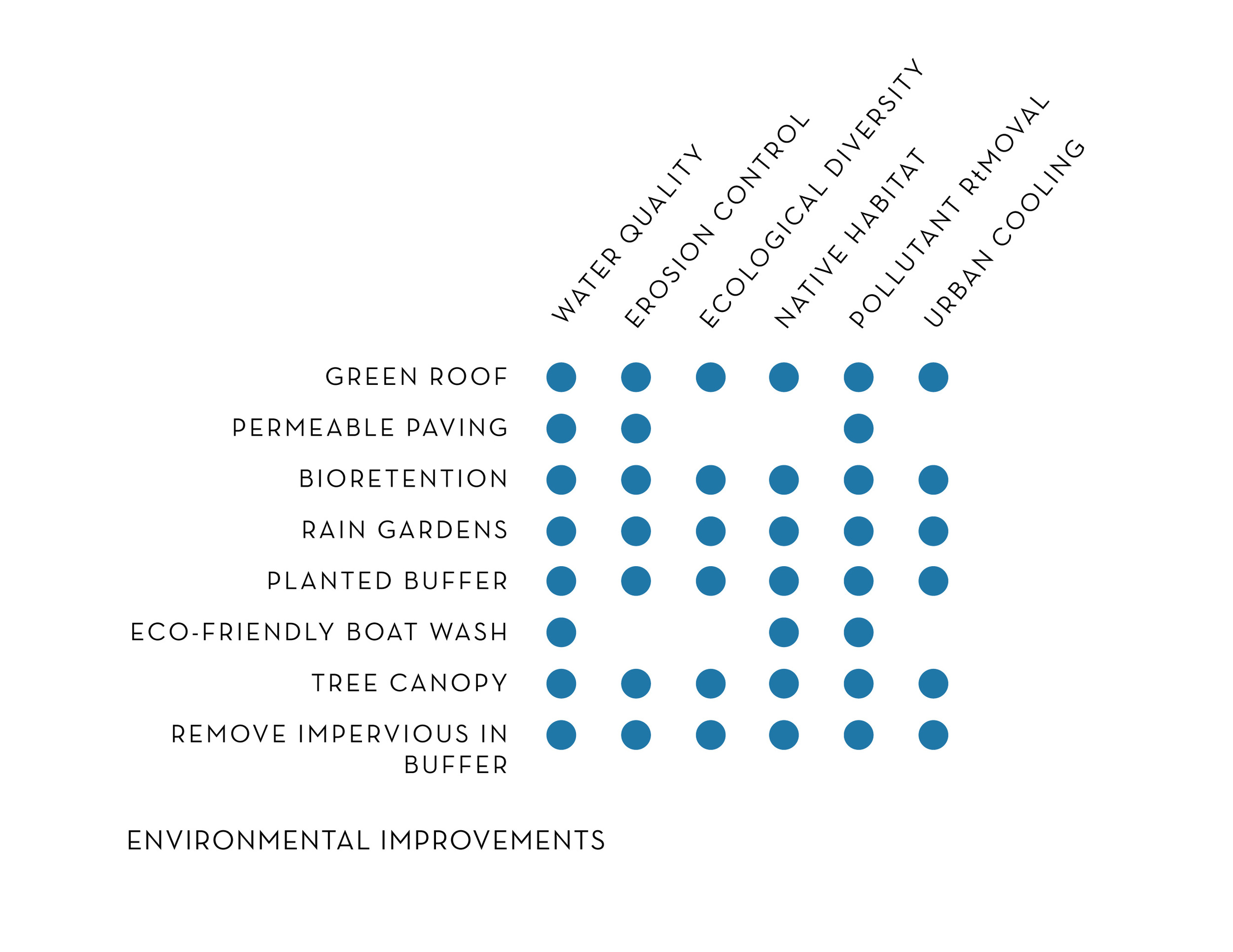
The site currently has zero stormwater management which means 55,000 gallons of unfiltered water flows into Spa Creek during every 1” storm event. Using a variety of strategies including pervious surfaces, rain gardens, a green roof, storm filters, and micro-bioretentions the site will remove 65% of pollutants compared to the 10% that is required. The new site will drastically improve the environmental effects as compared with the site’s current existence. View the LEARN MORE section to find out additional information under the Environmental Impact section.
- There will be a reduction of impervious coverage within the 100 ft. buffer by 17% (9,393 sq. ft.).
- Approximately, 20,000 square feet of covered boat houses will be removed from the water frontage within Spa Creek, thereby reducing shading effects over potential submerged aquatic vegetation (SAV) habitat by approximately 0.46 acres. This will allow for regrowth and support marine life and a healthier Spa Creek.
- A Marina Boat Wash Wastewater Containment and Treatment system will be provided where there is not one in the existing condition.
The traffic impact in the surrounding community will actually be less than it is now. We had consultants conduct a traffic study and they reported that there are 1277 daily trips made to the marina currently. After the redevelopment there will be 1138 daily trips. The traffic to the residential units will be exactly the same as it is now since we are just replacing the exact number of residences as currently present.
What traffic implications will there be?
Will the harbor line change?
The marina, docks, and boat slips have had the same configuration as today since at least 1974. Harbor lines are typically created from connecting stationary objects like piers or other fixed objects on the edge of the waterway. In 1980 official harbor lines were created by the City of Annapolis in Spa Creek for this area. There was an error made at this time when creating a small section and an indent was recorded as the harbor line instead of a straight line. The most likely reason for the mistake was that the aerial view at that time did not pick up on some of the existing conditions located in that area.
We are requesting that the harbor line be corrected to include the yellow portion shown in the images below to accurately represent the harbor line that has been active for at least the last 42 years. We are asking only that the mistake be corrected officially to accurately represent what has been and is there currently. Otherwise the harbor line will not move or be affected in any other way with the new marina. Click each image to enlarge.
As you can see below, T-head will be Positioned to allow boats to still dock at the end and be within the corrected harbor line.
Aerial View of Harbor Line in 1974
AERIAL VIEW OF HARBOR LINE IN 1977
AERIAL VIEW OF HARBOR LINE IN 1985
AERIAL VIEW OF HARBOR LINE Currently
Will boat movement on Spa Creek be affected by our requested harbor line correction?
The portion of harbor line in question has zero effect on safe passage or navigation in the existing waterway. As seen from the image below, the channel is marked by the channel marker and the bridge. Even with the corrected harbor line, boats in their slips at the new South Annapolis Yacht Centre will reach no further into Spa Creek than they have for the past 42 years. Click image to enlarge.
Will there be an increase in the number of boat slips available?
There are currently 85 slips at the marina now. There will actually be a decrease to 69 slips which means we anticipate less boat traffic on Spa Creek. Additionally, the goal of the marina is to have 100% annual slips as opposed to transient slips which means less coming and going from the boat owners.
How many residential units will be incorporated into the new marina village?
Eleven new water view homes will replace already existing residences. There will be six single family residences, one duplex, and one triplex all replacing the same type home that currently resides on the property. The design will integrate the pattern language of Eastport and incorporate materials, and gable or hip roof shapes will emulate those traditionally found in Eastport. There will be two off-street parking spots included in the plans for each residential unit.


Will the site allow for traffic to flow through State St. to access Washington St. and Boucher Ave.?
No through traffic will be allowed through State St. The section of State St. that goes through the SAYC site will end with a section marked with bollards blocking any through traffic. These will be removable only in an emergency situation. Otherwise, the site will not provide access through State St. to Washington St. or Boucher Ave. Please view the site plan image below the next question.
What is the parking strategy for the new SAYC?
Each residential home will have two off-street parking spots. There will also be adequate parking to accommodate the marina and commercial maritime buildings eliminating the need for any street parking in the community.
Is a restaurant a part of the marina centre?
There is not a restaurant present in the site design review submittal.
Is there reason to believe that there will be an increase in noise that will affect neighbors and residents across the creek?
No, the overall number of boat slips are being reduced, and the increase in commercial maritime office space cannot reasonably be expected to cause an increase in noise heard by either side of the creek.